Understanding Our Underground Water
Water in La Paz County doesn’t only exist in rivers and canals. Much of it is stored underground in aquifers, natural formations of rock, sand, and gravel that hold water beneath the surface.
For many rural communities in the county, groundwater from aquifers is the primary local water supply. Understanding how aquifers work, how they are used, and how they are managed is essential for protecting our long-term water future.
The Water Alliance of La Paz County works to connect residents with clear, trusted information about local groundwater systems so communities can better understand the resources beneath their feet.
What Is an Aquifer?
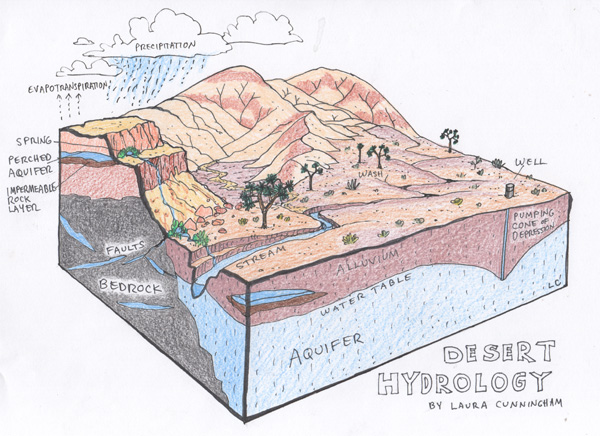
An aquifer is a layer of underground rock, sand, or sediment that stores water and allows it to move through small spaces between particles.
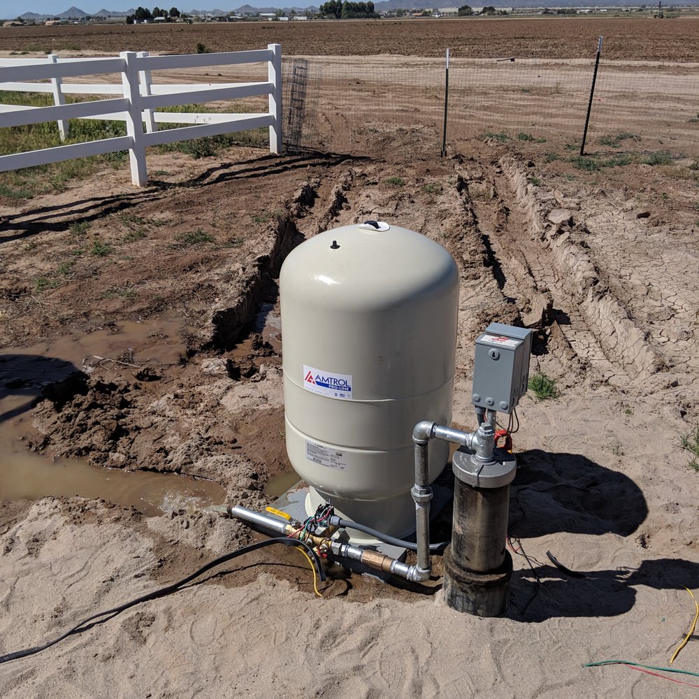
Aquifers function like natural underground reservoirs. Wells tap into these formations to pump water for homes, agriculture, and industry.
There are two main types of aquifers:
Unconfined aquifers
- Located closer to the surface
- Water levels rise and fall more quickly
- Recharged by rainfall, rivers, or surface water infiltration
Confined aquifers
- Located deeper underground
- Trapped between layers of rock or clay
- Often contain very old water that accumulated thousands of years ago
In many parts of western Arizona, including La Paz County, groundwater may be fossil water — water that entered the aquifer long ago and is not quickly replenished.
Aquifers in La Paz County
La Paz County lies within several groundwater basins that store water underground in large sediment-filled valleys.
Major groundwater basins in or near the county include:
Ranegras Plain Groundwater Basin
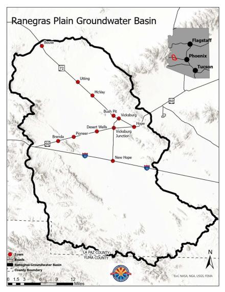
- Active Management Area (AMA) Status: Designated as an AMA in January 2026 to protect against overpumping, this designation imposes mandatory groundwater measurement, reporting, and management plans, notes the Environmental Defense Fund.
- Location and Features: The basin is located in west-central Arizona, bordered by the Harquahala, Plomosa, and Harcuvar mountains. It is primarily rural but contains a large, concentrated area of agricultural activity southwest of Vicksburg, notes Arizona Department of Water Resources.
- Water Level Declines: The basin is classified as a “priority” area due to severe declines, with some wells showing drops of over 200 feet since the 1980s.
- Agricultural Impact: The area hosts heavy agricultural use, including large-scale alfalfa and jojoba farming, which creates significant drawdown (a “cone of depression”) in the groundwater table, according to the Arizona Department of Water Resources.
- Water Characteristics: Groundwater is found in both Quaternary alluvium and Tertiary deposits, with annual natural recharge estimated to be roughly 7,000 to 8,000 acre-feet, which is significantly less than recent pumping levels, research from FHSU Scholars Repository explains.
- Recently designated as an Active Management Area (AMA) by the Arizona Department of Water Resources in 2026. https://www.azwater.gov/designation-process-ranegras-plain-groundwater-basin-ama
- The designation was made due to concerns about groundwater levels and long-term sustainability.
- Future groundwater use in the basin will be subject to additional management and planning.
McMullen Valley Basin
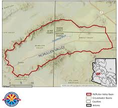
- Location: Spans western Maricopa, eastern La Paz, and southern Yavapai Counties, bounded by the Harcuvar Mountains to the north and Harquahala/Vulture Mountains to the south.
- Water Crisis: The basin is experiencing severe depletion, with water levels dropped up to 300 feet since the 1940s, primarily due to agriculture.
- Subsidence: Intense groundwater pumping has caused the land to sink over 4 feet in some areas since 1991, affecting towns like Salome, Wenden, and Aguila.
- Water Export: The McMullen Valley is a designated transfer aquifer where cities (e.g., Phoenix) have purchased land and water rights to transport groundwater to the Phoenix Active Management Area.
- Demand: Approximately 99% of the demand is agricultural, and it is considered an area with insufficient supply to meet current demand.
- https://www.azwater.gov/sites/default/files/2023-12/2023_McMullenValleyBasin.pdf
Butler Valley Basin
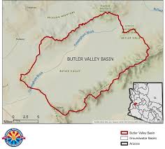
- The Butler Valley groundwater basin is in a remote area in Western Arizona within La Paz County, and spans 288 square miles.
- Groundwater flows toward areas in the basin where pumping is concentrated and southwest along the Cunningham Wash drainage towards the Ranegras Plain basin.
- The Butler Valley basin is largely uninhabited. However, there is a significant amount of agricultural groundwater use as of 2023, with 3,100 acres in cultivation.
- https://www.azwater.gov/sites/default/files/2023-12/2023_ButlerValleyBasin.pdf
- https://www.azwater.gov/sites/default/files/2025-11/Butler%20Valley_0.pdf
Harquahala INA
- Location: Located near Tonopah, Arizona, it is bounded by the Harquahala, Big Horn, Eagletail, and Little Harquahala mountains.
- Purpose: It manages areas with declining groundwater, limiting new irrigation on land not cultivated in the five years prior to 1981.
- Water Usage: Agriculture is the primary water user, though the region is a source for transporting water to more regulated areas, such as the Phoenix Active Management Area (AMA).
- Governance: Administered by ADWR, it often involves the Harquahala Valley Irrigation & Drainage District (HVIDD), which covers 33,500 irrigable acres.
- Recent Developments: Legislation has allowed for the transport of groundwater from this area to other areas, raising concerns about local sustainability.
- https://www.azwater.gov/sites/default/files/2023-12/2023_HarquahalaINA.pdf
Tiger Wash Basin
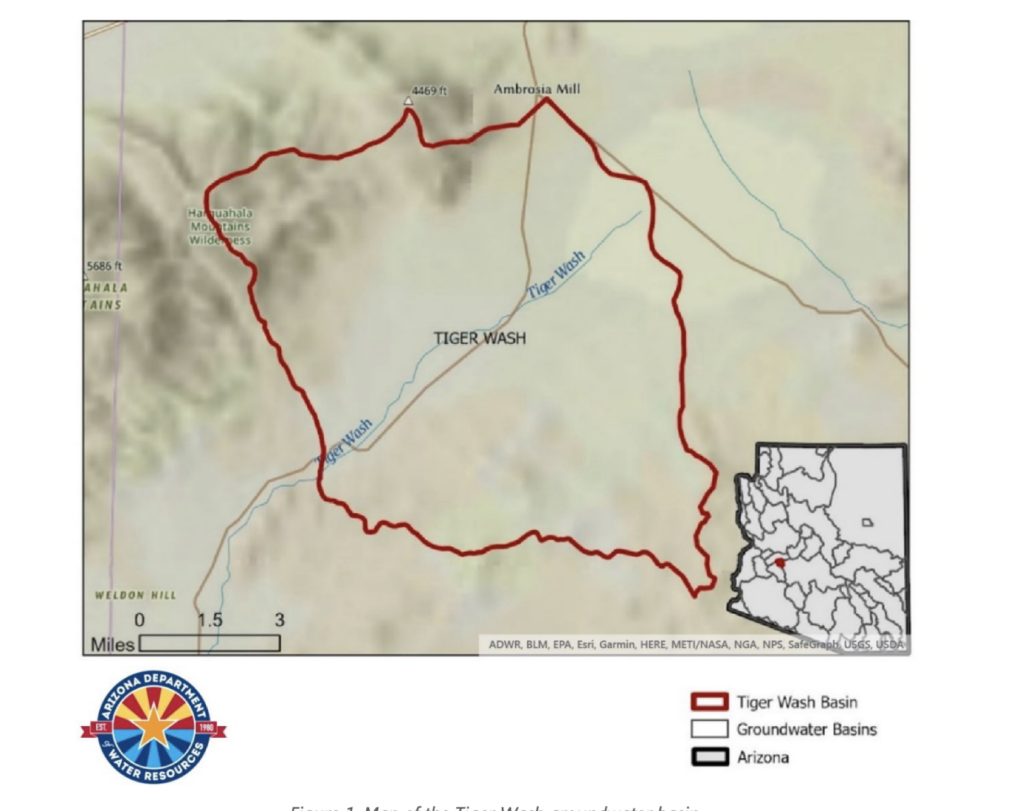
- Location: Situated west of the Phoenix Active Management Area, it lies in a largely uninhabited area near Tonopah and the Mindat website notes it is near the Osborn Mining District.
- Geography & Hydrology: The basin is characterized by Arizona Department of Water Resources (.gov) as a catchment area with groundwater flowing toward the Hassayampa subbasin.
- https://www.azwater.gov/sites/default/files/2023-12/2023_TigerWashBasin.pdf
These aquifers formed over thousands to millions of years as sediments washed down from surrounding mountain ranges and filled valley basins.
Why Aquifers Matter
Aquifers support many parts of daily life in La Paz County:
Drinking water
Many rural homes rely on private wells.
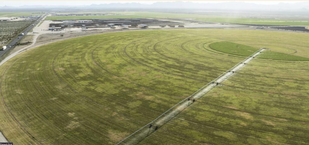
Agriculture
Farms depend on groundwater irrigation.
Economic development
Businesses and industry require reliable water supplies.
Community resilience
Groundwater provides a buffer when surface water supplies fluctuate.
Because some local groundwater is not easily replenished, careful management is essential to ensure water remains available for future generations.
Groundwater in Arizona
Arizona manages groundwater differently depending on location.
Some areas of the state are designated as Active Management Areas (AMAs) where groundwater withdrawals are regulated to prevent depletion. (https://www.azwater.gov/ama/active-management-area-overview)
Historically, much of La Paz County was outside of AMAs, meaning groundwater use was less regulated. However, this is changing as water concerns grow in parts of western Arizona.
The designation of the Ranegras Plain AMA represents an important step in regional groundwater management. (https://www.azwater.gov/designation-process-ranegras-plain-groundwater-basin-ama)
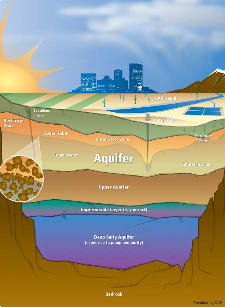
How Aquifers Are Recharged
Aquifers gain water through a process called recharge, which occurs when water moves downward into underground formations.
Recharge sources can include:
- Rainfall soaking into the soil
- Floodwaters from washes and rivers
- Irrigation return flows
- Managed recharge projects
In arid desert environments like La Paz County, natural recharge happens slowly, which is why long-term water planning is important.
https://www.amwua.org/blog/groundwater-the-growing-challenges
How Aquifers Are Monitored
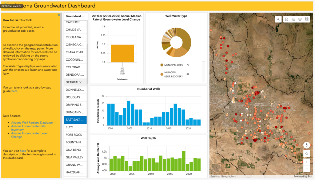
Groundwater conditions are tracked through:
- Monitoring wells
- Water level measurements
- Pumping reports
- Scientific studies
These measurements help water managers understand trends such as:
- Falling water tables
- Aquifer depletion
- Changes in water quality
https://azdeq.gov/GW_quality_n_monitoring
https://www.azwater.gov/statewide-monitoring-program
https://azwaterblueprint.asu.edu/news/arizona-groundwater-dashboard
Learn More About Arizona Aquifers
The following organizations provide trusted research, data, and educational resources about groundwater and aquifers in Arizona.
University of Arizona – Water Resources Research Center (WRRC)
Provides research, educational materials, and community outreach programs on Arizona water systems.
Topics include:
- groundwater science
- aquifer recharge
- water policy
- rural water sustainability
Arizona Department of Water Resources (ADWR)
ADWR manages groundwater regulation and provides maps and reports on groundwater basins and Active Management Areas.
Resources include:
- basin maps
- groundwater reports
- AMA planning documents
ASU Arizona Water Innovation Initiative – LABrary
https://azwaterinnovation.asu.edu/labrary-iwa
A curated digital resource library providing tools and information about water management, innovation, and policy in Arizona.
The LABrary includes:
- water management guides
- research reports
- case studies
- educational resources for communities and decision makers